Mingsheng Aluminum Sheet Home > faq > Aluminum Alloy > Road signs for multiple exits in close proximity in Japan
Road signs for multiple exits in close proximity in Japan
Author:Aluminum Sheeting for Trailers_Aluminum Trailer Siding Sheets_Mingsheng Aluminum Update time:2025-04-26 08:10:01(2) Wayfinding Signs Installed on Mainline Road Sections
There are other types of wayfinding signs installed on mainline road sections between interchanges of motorways, and the focus here is on location distance signs, location signs and service facility signs.
1) Location Distance Signs
Japanese location distance signs are usually made of assembled panels, with slits reserved for wind penetration to reduce the impact of wind on the sign, and are easy to remove and replace. One message is set in each cell to create a natural separation, and they are generally arranged in the order from near to far and from top to bottom. The distance sign is generally set up in the mainline section between 2 interchanges, it mainly forecasts the name and number of the exit in front, or the places and routes that can be reached, and at the same time, it shows the distance to these destinations on the right side of the sign face.
2) Location sign
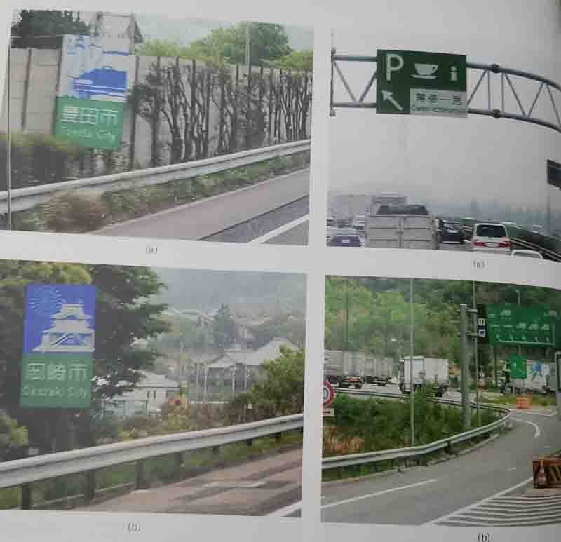
When the motorway passes through some administrative areas, such as prefectures, cities, towns and villages, a location sign is set up at the boundary of the area, which is also one of the most characteristic signs on Japanese motorways. The sign face is divided into two parts, and the lower part displays the name of the region in a standard format of white characters on a green background, with Japanese and English cross-referenced forms, such as: 都 ( Met .) 道府县 (Pref .), 市 (City), 町 (Town .) 村( Vil .)The upper part of the plate displays the name of the area in Japanese and English, such as: Metropolis, Prefecture, City, Town, Vil. etc.; the upper part of the plate shows the most symbolic image pattern of the location area.

( a ) Toyoda City, one of the cities in Aichi Prefecture, Japan, has developed into an industrial city centred on the automobile industry since the arrival of Toyota in 1938, and since Toyota automobiles are famous all over the world, the symbol of the location shows an automobile motif.
( b ) Okazaki City, Abasaki Castle is the focal point of sightseeing in Abasaki City and is the birthplace of Tokugawa Ieyasu, the shogun who united Japan, founded the Edo Shogunate in 1603 and ended Japan's 260-year warring states era. Priding itself on its history, Abasaki Castle occupies an important role in Japan's history, which is why the location symbol is represented by the Abasaki Castle motif.
3) Service Facility Signs
The service facilities on Japanese motorways are very well developed, with one being installed every 25-30km, and simple parking areas and fully functional service areas are laid out in a staggered manner. Within 1-2km before the entrance to a parking area or service area, a service facility advance notice sign and an exit indication sign are usually installed. The service facility signs display the name of the service area or parking area and show the main services, such as parking, refuelling, catering, etc., in a simple pattern.
(3) Proximity multi-exit preview method
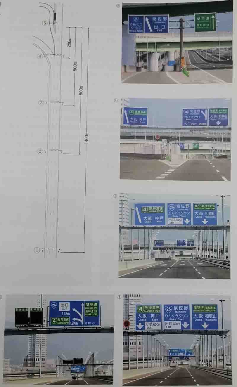
In Japan, Tokyo, Osaka and other international metropolitan area, the motorway crisscrosses, various forms of interchanges overpasses tumble, dazzling, they are up and across the bottom through, spectacular. The characteristics of the metropolitan area motorway is more entrances and exits, often in a short distance continuously 2 or 3 entrances and exits, in fact, this situation in the domestic Beijing, Shanghai, Guangzhou and other major cities will often see. With multiple exits in close proximity, it is not possible to start to foretell exits one or two kilometres in advance, as in the case of peripheral motorways, but how to foretell several exits at the same time is a difficult task for the installation of wayfinding signs. On the Kansai International Airport Expressway, there is a group of signs that simultaneously announce two close exits, and it is worthwhile for us to study and learn from the way it is handled. In Japan, this airport highway is called the Kansai Airport Expressway (KAI), and its directional signs have a special light blue background and white text. The setting of this group of signs.

① Point ① is a general warning sign featuring a three-pointed arrow pattern that simultaneously displays the most representative information about the two exits and the direction of travel on the main line. This point is 1.2km away from Exit 1 and is directly connected to the Hanshin Expressway, so it is called ‘JCT’ in Japan. It is 1.4km away from Exit 2, and after the exit, you can directly enter the general road National Route 26, which is called an exit (EXIT) in Japan when you enter a low-grade road from a high-grade road.
② ② ② Point ② is a combination of lane indication and exit warning sign, which is characterised by two aspects: firstly, the allocation of lanes is made clear by vertical downward arrows, with the left lane leading to Exit 1 (divergent JCT .) The middle lane leads to Exit 2 (EXIT ), and the right lane is mainly provided for the straight traffic; secondly, the corresponding location information is added to the two exits and the straight direction, forming a combination of information forecasting for the reachable destinations and via the road.
③ ③ Point ③ is a comprehensive wayfinding sign integrating exit indication, lane indication and exit forecast. This point is very close to Exit 1 (Divergence JCT.). It is very close to Exit 1 (Divergence JCT .), so an upward sloping arrow is used to indicate the direction of travel to the exit, signalling the driver to slow down and enter the exit ramp in advance.
④ Point ④ is changed to a dark blue wayfinding sign to create a certain visual contrast effect, reminding drivers that they have entered the critical part of the exit. For Exit 1 (Divergence JCT .) It is located at the triangular end of the exit; for Exit 2 (EXIT) only 200m is left, so it adopts the combination of exit indication and exit preview, and the arrow pattern is very simple and easy to understand.
(4) Point ⑤ is the exit indication sign for Exit 2 (EXIT), which is set at the triangular end of the exit with a T-shape structure. The amount of information at this point is already less than that of the previous sign, and it focuses on indicating the exit direction and exit information, while taking into account the information of the main line forward direction.
(4) Variable Message Signs
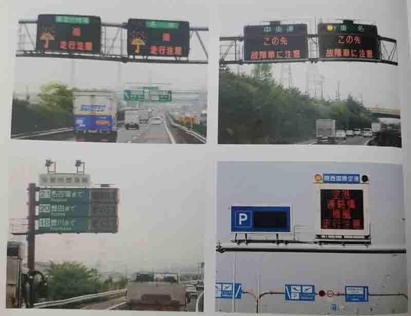
The focus of this book is on static wayfinding signs, but the coordination and functional complementarity between dynamic variable message signs and static wayfinding signs in Japan are still worthy of our study and attention. For vehicles travelling at high speeds on motorways, any incidental events occurring on the road section, such as traffic accidents, vehicle breakdowns, climate change, road maintenance, and cargo dispersal, etc., will quickly affect the following vehicles and easily cause secondary accidents. Dynamic variable message signs can effectively make up for the shortcomings of static signs, it can real-time and accurately release the information of these incidental events to ensure driving safety. Variable message signs in Japan convey a large amount of information, including climate change, natural disasters, traffic accidents, traffic control, traffic jams, estimated travelling time, traffic campaigns and other information.

Article Categories
New Article
Contact Us
Contact:Maddy
Add:No. 162 Jinbai Road, Zhengzhou City, Henan Province, China
